Friday, June 29, 2012

LA to St George Utah

Temperature driving through the Mojave Desert.
 Austin and I left Yosemite early in the morning after packing up our tent and other gear.  The trip to LA was pretty uneventful until we
Formations east of Las Vegas.

Formations east of Las Vegas.

Formations east of Las Vegas.

Formations east of Las Vegas.

Formations east of Las Vegas.

Enjoying a tasty Mexican dinner and flaming margaritas.

Roadside flowers in LA

Roadside flowers in LA.

Roadside flowers in LA.

Roadside flowers in LA.

Roadside flowers in LA.

Thursday, June 28, 2012

Yosemite: May Lake Trail


June 18, 2012
This day was dedicated to the north central part of the park, which we accessed by a long drive first toward the valley, then west, and finally east on the Tioga Pass road.  After about 15 miles on that road, which was laid out by John?  Olmsted, we stopped at a trailhead for a hike to May Lake.  

May Lake and Mt. Hoffman

Rocky terrain near May Lake

Overlooking May Lake

Mt. Hoffman

May Lake with the last patch of residual snow.

 The sign said 2.7 miles and the map showed that it wasn’t particularly steep, both of which sounded perfect 
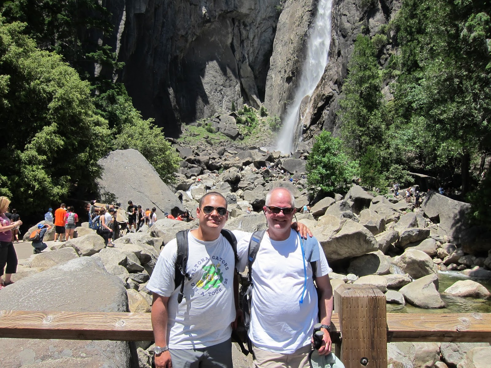
after our arduous climb up Yosemite Falls on the 16th.   As promised, the trail was relatively gentle, climbing through a sparse pine forest that has taken hold in the thinnest, least organic soil imaginable.  The girth of some of these trees approached six feet, which was impressive because of the soil and the 9,000 altitude.  Austin and I wondered if it was actually the lean soil that discouraged competition between trees that allowed the hearty ones to grow so well.  The trail proper was either soft, dry deep sand that was a little hard to walk in or smooth granite. 

Snow Survey cabin.
About a mile into the hike we crossed paths with a couple who asked us if we had a map.  I told them our map was safely in the car where it belonged, which is where theirs was as well.  They said they had walked 2 ½ miles and did not find the lake, instead they turned around at a surveyors cabin.  Taking this in mind, we kept our eyes out for a cross trail that they might have missed.  Seeing none, we kept walking until we reached the cabin that was intended as refuge for snow survey crews. Since we had walked neither 2 1/2 miles or felt the least tired, we continued onward, rising gently through beautiful groves of trees.  Shortly, we came across a construction crew that was clearing a parking area.  This seemed more than a little odd and left us a bit discombobulated.    

Granite and pines near May Lake
Crossing the work area the landscape transitioned to vast open expanses of cracked and blocky, gray granite.  The vistas opened up as well: a ridge lay before us, with a peak just behind, a perfect place for a mountain lake.  Turning about, gently curved but incredibly massive rock surfaces stretched for miles in all directions.  The bowels of the earth have inched their way to the surface, stretching and expanding, pushing higher until all but the heartiest life has been shed. From here, the lake is little more than 1/2 mile up the ridge on a couple of easy switchbacks.  The lake is fairly small and nearly circular surrounded by signs warning not to swim because it is the water supply for Yosemite Park.

Me and Austin
There were several groups camping near the lake and two canvas-sided cabins on the northwest side, called the May Lake High Sierra Camp, as we later learned.  The lake sits at 9,270 feet and is lorded over by Mt. Hoffman, towering to 10,850 feet.  We decided to continue up to the shoulder of the mountain to see if the views improved.  The trail was a little steeper but still quite manageable. After about 1/2 mile the terrain flattens in an expansive high mountain meadow, rising to the west is Mt. Hoffman, and to the east a low ridge. We decided to leave Hoffman for another trip and ambled over to the ridge which offered and amazing view of the batholith and a fleeting view of the lake below.

After a short stay we returned to the car and continued our drive east, rising through Tuolome Meadows and on to Tioga Pass.  The return trip to Wawona Campground was uneventful but long, it must have taken two hours to drive.  It gave us a sense of the enormity of the park, especially when we realized that we had seen less than half of it.


Austin admiring his cairn creation.


Saturday, June 23, 2012

Yosemite Park Site seeing June 17, 2012


Austin got more and more comfortable driving a stick (and so did I)


After yesterday’s tiring hike we decided to enjoy a more leisurely day seeing the sites.  Austin drove most of the day and really started to get a feel for the clutch.  The first stop was Glacier Point, high above the south side of the valley.  From that vantage, there are magnificent views of Half Dome, Yosemite Falls, and peaks in the northern distance.  


Geologic map of Yosemite Valley.
 An exhibit explains the geology of the area, which began with batholithic intrustions about 100 million years ago, followed by episodic glaciation that carved and shaped the valley until the last 20,000 years or so.  The Sierras are still rising about a foot every 1,000 years.

 Next we stopped at the Wawona tunnel overlook, which offers a vantage of the valley from some 1,000 feet lower. 

Wawona tunnel
 Here Yosemite Falls is front and center, with nary a reminder of the pain it laid down the day before.  At the bottom of the valley we veered right and did a short hike to the base of Bridal Veil Falls, which is only of the many popular sites along the way.  Hundreds of visitors lined the trail, some enjoying snacks, some wading in the creek, and some scampering up the rocks to get closer to the falls.  

Slice of an old tree.
The rest of the afternoon we explored the village, stopping in at the Ansel Adams gallery to see the work of the master first hand. Next we explored the museum, admiring the basketry of the local Indians. Up until the 1940s, there was an Indian show to entertain the visitors during the summer. It was discontinued because of the cost and the growing sense that it was inauthentic.   There were a number of interesting things to see including a slice of a tree that is well over 1,000 years old and a cemetery with dozens of graves from infants to old men.
Grave in the Yosemite cemetery.
 

We wrapped up our afternoon in the village by watching a video “The Spirit of Yosemite”, which covered the natural history and park development process spurred by John Muir and Teddy Roosevelt.  


 We made our way to the Mariposa Grove in the southwest corner of the Park.  Here an easy trail winds through a grove of sequoias that are up to 2,000 years old.  In the last few decades, the NPS has begun to manage the understory with fire, which is a big change for the conservation community.  The largest tree in the grove is called the Grizzly Giant.  One of its lower branches is
 
to the Wawona campground and set up camp as the light faded.  We cooked up a batch of one-pot pasta with marinara sauce on our new MSR stove and it turned out great.  Our first night sleeping in the tent was a bit of an adjustment.  It had been a while since either of us had slept on hard ground and both of us rolled half the night.  Austin was delighted when I rose at 6am because it gave him the chance to sleep a couple of hours on my slightly more cushy pad.  

Yosemite Falls Trail


View at Lower Yosemite Falls.


Yesterday was my first day in Yosemite National Park.  Austin and I arrive about 1130 after spending the night well outside of the Park.  After parking we look a shuttle to the Lower Yosemite Falls trail, which is a short, flat loop.  The view of the falls and the spray was spectacular and got us motivated for a longer hike.
Climber descending face near Camp 4.
  So, we chose the Upper Yosemite Falls trail which begins about ½ mile down valley.  We walked by several rock faces that were being ascended by a couple of pairs of roped climbers. Soon enough the trail proper veered to the right up a steep, wooded draw.
Steep grade near the start of Upper Yosemite Falls trail.
  The trail is sculpted from granite, reportedly beginning in the 1850s. In many places the footpath is a series of stairs that are flanked by expertly constructed retaining walls.  The amount of work that would have been required to construct it is mind-boggling.
Beautiful rock retaining wall.


Also mind-boggling is the grade, which is probably between 20 and 30 percent in most places.  The trail is a series of very short switchbacks, sometimes no more than 30 feet long.  After an untold number of these (80?, 1000?) the trail flattens just a bit and heads east toward the falls. All along this section of the trail the views are spectacular, both of the verdant meadows in the valley and the granite walls on the opposite site of the valley.  After a few more switchbacks up the trail levels again and then drops a few hundred feet as it round a corner, bringing the base of Upper Yosemite falls into view.
Upper Yosemite Falls

The view is spectacular as the wind blows the cascading water off of the granite face where it plunges some 1,430 feet.  Then, the realization that the trail has to achieve that same elevation was daunting at best.  Two groups of hikers were resting in this area and each one nearly convinced me to throw in the towel and enjoy the view from below.  The lower hike had been fairly brutal because the temperature was in the upper 80s.   Austin had a different plan though and was excited to continue up.
Intricate rock trail on upper section

Sign at the top of the trail

Rest spot at the top of the trail.

The trail follows another mostly wooded draw between two massive granite walls.  One switchback after another, and another led us to the top.  We crossed paths with many hikers and a few campers along the way as this is a very popular route.  We grew increasingly tired as we neared the end of our journey: the heat, the altitude, and our lack of fitness, combined to take a toll on each of us. The trail splits at the top, the way to the right leads to an overlook of the valley and a bit farther to the creek.  It was quite a relief to pull off the boots and dip ones toes into the cool water. 
Yosemite Creek above the falls

Yosemite Creek above the falls.

The trip down seemed endless. Each of us had run out of water in spite of having well over a gallon between us.  Although faster and not a cardio work-out the steep grade takes a different toll.  After giving regards to a young, fit couple who passed us on the way up and were waiting, apparently well rested at the bottom, we found water at the Camp 4 campground.  We trudged our way back to the car, grumbling about our pain but grateful for the experience.

Wednesday, June 13, 2012

Dirty Harrry's Balcony

After last week's detour to Putrid Pete's Peak, it was time to seek out Dirt Harry's Balcony.  The trail begins at the Ira Springs trailhead which is reached by from I-90 Exit 45.  The trail for Dirty Harry's Balcony continues straight west at the first switchback. 

The first 20 feet of the trail have been obscured by branches laid down to keep hikers heading up to Mason Lake or Bandera.

 Ignoring the barriers leads to a nice trail along contour, rising slightly but generally an easy go.  At about 1 mile from the start, at the second of two sign-marked left turns, the trail to the "Balcony" drops away below the P3 trail.

Beyond the junction the trail is relatively easy to follow but a lot sketchier than the previous section.  It drops elevation more than one would anticipate heading to a balcony so it was pretty easy over all.  At about 1 1/2 miles, the landscape transitions to a wide gently sloped area and the trail become harder to follow.  Trees have been etched to indicate the way, On the left a small rise became visible that could have been the "balcony".

  It offered a nice overlook of McClellan's Butte and I-90 and a rocky prominence about 1/2 mile further west that was occupied by a hiker, so surely that had to be the true destination.  I left the "Faux Balcony and continued on until I hit a well defined trail at a bending tee.  The way to the Balcony is to the left another 100 yards or so.