Saturday, August 27, 2011

Crystal Lake and PCT


Today I went someplace I rarely go unless there is lots and lots of snow on the ground. I headed south on 410 and drove about 5 miles further into Mount Rainier National Park. Although it was offbeat for me, everyone in the Pacific Northwest seemed to have the same idea. Highway 410 is in NPS no-mans land, neither a park entrance fee nor a NW Forest Pass are required to park legally- who said nothing's free!
The Crystal Lake Train is a fairly steep but well maintained.  The first mile and a half climb through surprisingly young and uniform trees.  Although the shade was nice, it seemed a bit like hiking through a tree farm.  Slowly the character of the vegetation surrounding the trail changed and purple flowered lupine filled the air with a delightful scent.  In a couple of spots along the way the tree cover opened up and Mt. Rainier was spectacular.
Mount Rainier looking glorious!
Crystal Lake Trail
Shortly, I came across the first and only junction: the trail to Crystal Peak turned to the right but I decided to leave it for another day.  Soon I was upon Lower Crystal Lake and after another 1/2 mile I reached Upper Crystal Lake.  I turned right toward the few camping spots and followed a trail right on the lakes edge.  I noticed a frog and a salamander holding still in the shallow water.  Across the lake, a young family were enjoying the sun and water.

At this point the trail petered out and I decided to go off trail for a bit. I worked my way up through trees and grass until I reached a hillock that offered a panoramic view of the lake, the lake basin, and the surrounding peaks.

I spotted a faint trail to the northeast but gaining the trail would have required scrambling across a boulder field, which seemed unappealing.  I took a lower, grassier route which lead to a steep but manageable gully.  As I approached the top I heard voices from above, which after scanning the ridges, appeared to be a family, very near the South Back area of the Crystal Mountain ski area.
Family enjoying the warm side of Lake Crystal


Salamander and a frog chilling in the lake.


Spires above the Crystal Lake basin


Mount Adams in the distance
  I spotted a well-used trail that may have lead me in their direction, if only it had switched back to the left.  Instead it led me to another pass to the south, that connected to the Pacific Crest Trail (PCT), just over the pass.  From here it was all downhill, past a lake with dozens of people enjoying various activities including swimming, horseback riding, and fly fishing.  Overall, it was a spectacular day in the mountains.  I had another two miles to travel until I made it to Chinook Pass where I noticed a slide zone on the left side of highway 410 and the famous wooden bridge capping Chinook Pass under construction.  


I
Horses enjoying a break


I stuck out my thumb and after a ten minute wait I got a ride back to my car from pleasant fellow who had been scouting for the upcoming bow-hunting season for elk. I was tired from the heat so I stopped for a mocha shake in Greenwater as a prize.  It was an amazing end to the day!
Arch over Chinook Pass is being replaced.

Slide debris next to Chinook Pass

Monday, August 1, 2011

Snow Lake- Last Day in July

As cool as it has been this summer, it should have come as no surprise that Snow Lake was living up to it's name on the last day in July, 2011.  After last weeks extravaganza to Paddy-go-lucky Pass, I was grateful for a short hike to a reasonably short hike.

The lower section of the trail was clear of snow except a thin remnant where an avalanche had piled up earlier in the year. One and 1/2 miles in, the sign demarcating the junction with of the Source Lake and Snow Lake trails was clearly visible.  Only six weeks earlier, the sign was buried under six to eight feet of snow and there was no sign of the turnoff.  At that time, the only safe passage was to Source Lake- now the trail was clear but rocky as it climbed back toward the east.
Just above the Source Lake cutoff


Although the temperature was mild, a fine mist was falling. The cooling effect was pleasant and reminded me of how hot this exposed section of the trail can be on a summer day.  In fact, the switchbacks to the top seemed much gentler than I remembered from previous visits.
The stairs near the top were steep and water from melting snow created a constant drip along the path. 

Stairs near the summit

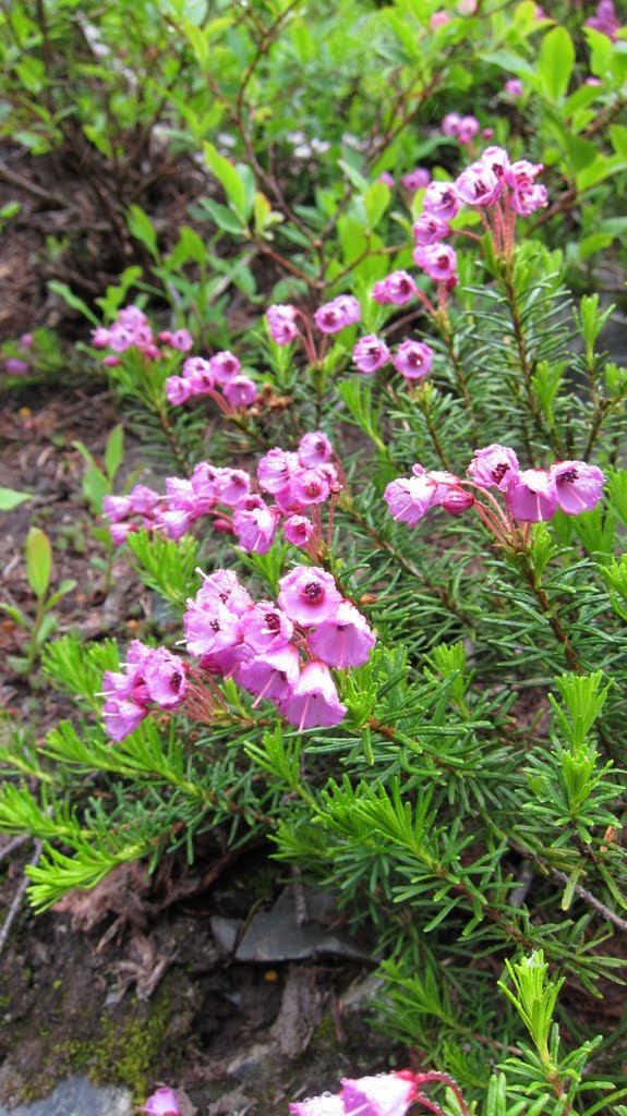
Flowers on the heather


The moisture and melting snow gave room for "spring" flowers, even on the heather.  A glance down provided a perspective on how steep this section of the trail is.  In places, the trail is cut from sheer stone. It must have been back-breaking work.


At the crest of the trail, the trail was covered with two to three feet of snow.  The lake basin was draped in fog and the lake was all but invisible 400 feet below.  I scampered about half way down to the lake and a few details appeared out of the gloom.  The lake remains covered with ice and snow except for a thin blue ribbon along the near shore.

Rather than hike all the way to the lake, I chose to climb about half way up one of the open snow fields.  I post-holed in next to a boulder and realized the snow was getting treacherous.  So, I pointed my boots down slope and skied back to the trail I used to wend my may down.
Cascading snow-melt from a face above the trail.


It was a short hike back and the temperature warmed to 70 degrees as the sky cleared.I stopped to admire a cascading torrent just across from Alpental.   It was nice to make it back to Seattle by mid-day instead of dinner time.