....
Wednesday, February 1, 2017
Friday, August 2, 2013
Cayuse Pass
Cayuse Pass is located within Mt. Rainier National Park and is accessible during the summer months when the road is not covered with snow. Most of the year, I find myself turning left up the hill to Crystal Mountain to ski. This time, I had a meeting in Yakima on Monday, so I decided to take a hike on the way to the east side.
The trailhead is located 4 1/2 miles down SR 123 from the tee with SR 410. The first 1/4 mile of the trail descends down toward Chinook Creek. Here I saw three hikers with backpacks leaving the trail, the only souls I would see for several hours when I was near the trailhead. First the roar of falls hits your ears and soon a set of Cascades peak through the trees on the right.
Just below the falls, the trail crosses the creek and begins working up the west side of the creek through old growth forest.
 I short time later, the trail splits, with one branch heading to Owyhigh Lakes and the other to Cayuse Pass. The latter was my destination for the day. The first part of the trail slopes up gently with a few downed trees that have to be hopped over. The next section was steeper with switchbacks. Soon, the grade becomes gentle and the first snow appeared. Although there were few visible tracks, it was easy to figure out which way one should go.
After about 3 miles, the trail crosses SR 123- remember to look both ways! At this elevation, in early July, the trail was almost entirely covered with snow. In a few places, the side slope was steep which made it important to pay attention to ones footing. Within 1/2 mile, the trail reached highway 410 a few miles below Chinook Pass. I couldn't find the continuation of the trail so I headed back to my car. All in all, it is a nice, lightly used trail. Enjoy it July through September depending on the snow year.
*-
The trailhead is located 4 1/2 miles down SR 123 from the tee with SR 410. The first 1/4 mile of the trail descends down toward Chinook Creek. Here I saw three hikers with backpacks leaving the trail, the only souls I would see for several hours when I was near the trailhead. First the roar of falls hits your ears and soon a set of Cascades peak through the trees on the right.
 | |
| Series of falls on Chinook Creek |

After about 3 miles, the trail crosses SR 123- remember to look both ways! At this elevation, in early July, the trail was almost entirely covered with snow. In a few places, the side slope was steep which made it important to pay attention to ones footing. Within 1/2 mile, the trail reached highway 410 a few miles below Chinook Pass. I couldn't find the continuation of the trail so I headed back to my car. All in all, it is a nice, lightly used trail. Enjoy it July through September depending on the snow year.
 |
| Large rotting cedar |
 |
| Scalloped snow |
 |
| Mt. Rainier popped into view. |
 |
| Two trees that fell in opposite directions from the same spot. It seemed odd to me. |
Sunday, March 3, 2013


Snowshoeing in Commonwealth Basin
I joined Ross, Karen, Ed, and Cindy for a day on snowshoes. The weather had been quite variable leading up to the weekend so I suggested we head for the Commonwealth Basin trail, which is pretty safe from avalanches. We met at Ross and Karen's and piled into Cindy's RAV4, complete with a stickshift! Chicks with Sticks Rule!
We stopped for a bio-break at the pass and found a fine parking spot at Summit West before crossing the road and making our way to the trailhead. After donning our shoes, we lined up for a group shot.
Ross led the way and we started up, up, up. None of us were all that experienced on SS but it was a first for Ross. There were a number of folks on the trail including several groups organized and led by the US Forest Service. The temperature was about 29 degrees and the sun was fighting through the clouds- sometimes with success and other times losing out to a light snow. Best of all were those moments when sun and snow shared the sky.
After an hour or so, with no clear idea of when the incessant grade would lessen, we decided to stop in a clearing for a lunch break. The tree behind the group was old growth and probably five feet in diameter. I scampered ahead to scout the trail and found that it flattened just a few hundred yards from our resting spot.
After navigating past a group of three skiers, who were returning from an afternoon higher in the hills, we stopped to admire the trail crossing the creek. In the summer, it is easy crossing the two-foot diameter log. As the winter season progresses, the log gets covered with a column of snow, which is passable by some, but we left it to braver souls.
We continued on for another quarter mile of so and stopped below Guye Peak for a photo op.
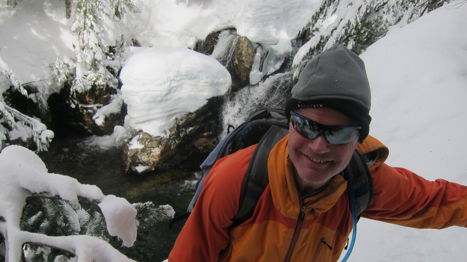
On the way down, we took a short detour to look at a waterfall on the creek. The snow pillow on the rock in the foreground is at least 5 feet high. It seemed a fine time to get a self-photo and Ed was kind enough to push the shutter. Luckily I did not back off the snowy precipice because the drop was about 20 feet and there is no easy way up the steep snow banks.
Guye peaked pokes in and out of view on the trail. It is a spectacular triangular summit that is visible from I-90 and separates the Alpental drainage from Commonwealth Basin.
When complete, we had trekked about 3.3 miles in 4 hours. Not bad for the first time on snowshoes for a few of us. It was another great day in the Pacific NW.
 |
| Google Earth Image of our track- 3.3 miles RT. |
We stopped for a bio-break at the pass and found a fine parking spot at Summit West before crossing the road and making our way to the trailhead. After donning our shoes, we lined up for a group shot.
Ross led the way and we started up, up, up. None of us were all that experienced on SS but it was a first for Ross. There were a number of folks on the trail including several groups organized and led by the US Forest Service. The temperature was about 29 degrees and the sun was fighting through the clouds- sometimes with success and other times losing out to a light snow. Best of all were those moments when sun and snow shared the sky.
 |
| Colin, Karen, Ross, Ed, and Cindy at the trailhead |
 |
| Steep going near the beginning of the trail |
After an hour or so, with no clear idea of when the incessant grade would lessen, we decided to stop in a clearing for a lunch break. The tree behind the group was old growth and probably five feet in diameter. I scampered ahead to scout the trail and found that it flattened just a few hundred yards from our resting spot.
 |
| Trekking across the flats. |
 |
| Crossing paths with back country skiers. |
 |
| A treacherous log bridge with at least 4' of snow on top. |
 |
| Ross and Karen below Guye Peak |
 |
| Ed and Cindy behind a snowbank. |
 |
| Waterfall on Commonwealth Creek |
 |
| Colin trying not to fall into the creek. |
 |
| Guye Peak. |
When complete, we had trekked about 3.3 miles in 4 hours. Not bad for the first time on snowshoes for a few of us. It was another great day in the Pacific NW.
Saturday, September 22, 2012
St. Helens Area Hike September 2012
As usual, the third Saturday in September is set aside for an open house at Classic Foods in Portland, Oregon. It was excellent weather, a great turn-out and delicious food. Typically, I spend the night in PDX and enjoy breakfast with Jake and friends. This time, I decided to try a hike near Mt. St. Helens. The day before I loaded up on maps at REI. One option was to try to summit but it is a permit based system with only 100 permits per day. Checking online, all of the permits were spoken for so I scaled back my expectations, which was probably for the best, because I was not really prepared for a rigorous climb.
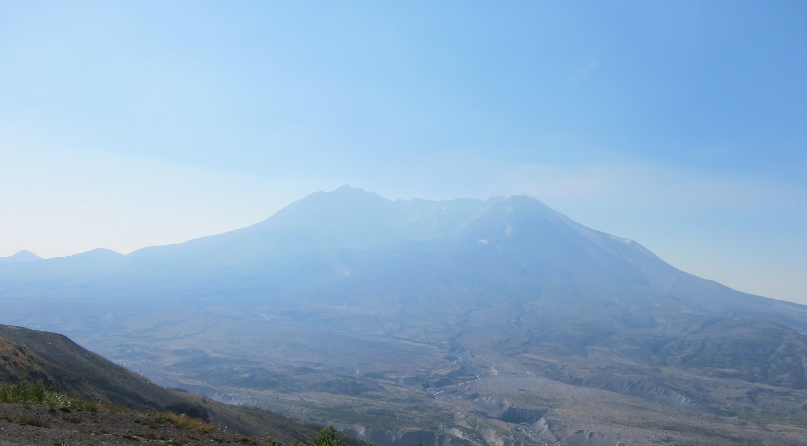
 Instead, I spend the night in Kelso and drove to the Johnson Observatory where the Boundary Trail accesses areas north of the mountain. The Johnson Observatory overlooks the blast path on the mountain and signs on the trail point out areas where the debris flows washed down leaving scars almost 500 feet up the side of the river valley. The mountain was shrouded in a smoky haze from a series of fires burning in the Mt. Adams area.
 The trail was dusty and smooth rolling down and up a ridge heading east. In some areas shrubs and grasses were beginning to take hold, in other places, the ground was still bare, more than 30 years after the eruption. Signs everywhere warned hikers to stay on the trail to preserve the natural recovery of the fragile landscape.
 The grade of the trail was gentle although in a few places it traversed a steep slope where a misstep would lead to a long, unfortunate roll down a rocky slope. A sign identified this section of trail as "more difficult" using a blue ski slope designation. On the return trip the same section of trail is labeled "most difficult" leaving one to wonder if there the trail designers perceived a directional difference or only had one of each sign.
I caught up with a German expat who was photographing the mountain. He told me that he had climbed St. Helens the day before and had picked up a standby permit the day before. Apparently there is no charge to reserve a permit which leads to a number of cancellations.From the spot where we chatted we could see Spirit Lake for the first time. The surface of the lake is covered with hundreds or perhaps thousands of weathered, gray logs blown into the lake during the 1980 blast.
 A short time later, the trail came to a tee; Peter headed down to the right and I continued up to the right. After traversing the northern flank of a ridge, the trail steepened slightly and switched back and forth across a colorful slope, dotted with red huckleberry bushes, grey stumps hinting at a violent end of their former selves, and a few new conifers.
 After clearing the ridge, the trail drops sharply and passes through a
keyhole passage in a jagged rock formation. The hole is about 20 feet
wide and 10 feet tall, creating a short tunnel on the top of a ridge.
After clearing the ridge, the trail drops sharply and passes through a
keyhole passage in a jagged rock formation. The hole is about 20 feet
wide and 10 feet tall, creating a short tunnel on the top of a ridge.

St Helens Lake pops into view at this point and it too is covered with logs that look like matchsticks from above.
About 1/2 mile past the keyhole, a spur trail heading to Coldwater Peak turns left and sharply up.

I could see the radio towers on the peak from miles away so I decided to give it a go. Soon, the trail became diffuse and splintered between the ripening berry bushes. I veered left, which turned out to be a mistake. Various tracks appeared only to disappear after a few yards. Based, on the scat, it seemed likely that bears rather than hikers had cleared the way. Unfortunately, my attempt to scale the peak was thwarted by a 50 foot vertical wall, on which sat an assortment of towers and antennae.
On the return trip, I looked back toward Coldwater Peak and noticed the hillside was covered with trees, blown down in an instant, by the incredible force of the volcanic blast.


I caught up with a German expat who was photographing the mountain. He told me that he had climbed St. Helens the day before and had picked up a standby permit the day before. Apparently there is no charge to reserve a permit which leads to a number of cancellations.From the spot where we chatted we could see Spirit Lake for the first time. The surface of the lake is covered with hundreds or perhaps thousands of weathered, gray logs blown into the lake during the 1980 blast.


St Helens Lake pops into view at this point and it too is covered with logs that look like matchsticks from above.
 |
| Logs on St. Helens Lake |

I could see the radio towers on the peak from miles away so I decided to give it a go. Soon, the trail became diffuse and splintered between the ripening berry bushes. I veered left, which turned out to be a mistake. Various tracks appeared only to disappear after a few yards. Based, on the scat, it seemed likely that bears rather than hikers had cleared the way. Unfortunately, my attempt to scale the peak was thwarted by a 50 foot vertical wall, on which sat an assortment of towers and antennae.
On the return trip, I looked back toward Coldwater Peak and noticed the hillside was covered with trees, blown down in an instant, by the incredible force of the volcanic blast.
 |
| Hillside littered with trees blown down by the volcanic blast. Coldwater Peak is in the left center distance. |
Saturday, July 7, 2012
Puke Loop
Fourth of July 2012-
My plan was to take an easy jaunt in the woods before heading to Jake's place on Bainbridge Island for dinner and drinks on the beach. Lake Talapus seemed the perfect destination: close and a gentle grade. FR 9010 provides easy access off of I-90. Several cars ahead of me were baffled by the signs closing the road to the Ira Springs trailhead but I was planning to turn right up the hill in any case. I was on the trail by 9:45 dipping from the sun onto the well shaded trail. The going was easy in spite of a few muddy sections which were easy to scramble over. The creek draining Talapus was swollen with snowmelt.
 Feeling great on such a spectacular day I bolted straight past Talapus, where a few campers were enjoying the morning by a campfire next to their tent.


 Onward to Lake Olallie, I found myself being paced by a younger hiker. After keeping him on my heels for a bit I waited and we chatted while hiking toward the higher lake. He had intended to go to Bandera but was stymied by the road closure. Soon enough, most of the trail was covered with firm snow, which was easy going and drier than the mud. We passed a hiker eying the creek crossing where the trail tees about a half mile below the lake.
Once we reached the lake we observed several couples enjoying the quiet view, which seemed nice enough but I had energy to burn. After parting ways with my unnamed acquaintance at the north end of Olallie, I continued up a faint, steep trail towards the Pratt Lake trail. After gaining the main trail I turned west and found myself behind another hiker. He seem unusually well equipped, and soon his walkie-talkie squelched out a message from the Forest Service. It turns out Steve is volunteer SAR (search and rescue) member. He was planning to go to Island Lake and I decided to tag along, completely forgetting my plan to take it easy. I guessed we might run into more snow and as the trail dropped around a corner from the high point the snow became quite thick.
About this time I mentioned to Steve that I had always wondered if it is possible to scramble down the outlet from Island Lake to Talapus, which according to his map is about one mile. We reached the lake following a few tracks and checking our way with his GPS unit. We were a bit to surprised to see someone there in front of us- it turned out to be the hiker who was trying to cross the creek below Olallie, whose name is Ian. We looked at the snow-covered lake for a bit and wandered over to the outlet creek. The slope to the left of the waterfall was steep but looked semi-passable.
About this time, I began to wonder whether it was a good or bad idea to be tagging along behind a SAR member. On the positive side, if I got into trouble I imagined that Steve would be good to have around; on the down side, I might be heading into something I wouldn't otherwise attempt without his fearless lead! Lead on he did, working his way diagonally down the slope using trees for bracing and spindly shrubs for handholds. A short time later we cleared the trees and stood on top of a steep boulder-covered slope. Steve scampered over the rocks like a mountain goat while Ian and I trudged on at a slower pace.
My plan was to take an easy jaunt in the woods before heading to Jake's place on Bainbridge Island for dinner and drinks on the beach. Lake Talapus seemed the perfect destination: close and a gentle grade. FR 9010 provides easy access off of I-90. Several cars ahead of me were baffled by the signs closing the road to the Ira Springs trailhead but I was planning to turn right up the hill in any case. I was on the trail by 9:45 dipping from the sun onto the well shaded trail. The going was easy in spite of a few muddy sections which were easy to scramble over. The creek draining Talapus was swollen with snowmelt.
 Feeling great on such a spectacular day I bolted straight past Talapus, where a few campers were enjoying the morning by a campfire next to their tent.
  |
| Lake Olallie |


Once we reached the lake we observed several couples enjoying the quiet view, which seemed nice enough but I had energy to burn. After parting ways with my unnamed acquaintance at the north end of Olallie, I continued up a faint, steep trail towards the Pratt Lake trail. After gaining the main trail I turned west and found myself behind another hiker. He seem unusually well equipped, and soon his walkie-talkie squelched out a message from the Forest Service. It turns out Steve is volunteer SAR (search and rescue) member. He was planning to go to Island Lake and I decided to tag along, completely forgetting my plan to take it easy. I guessed we might run into more snow and as the trail dropped around a corner from the high point the snow became quite thick.
About this time I mentioned to Steve that I had always wondered if it is possible to scramble down the outlet from Island Lake to Talapus, which according to his map is about one mile. We reached the lake following a few tracks and checking our way with his GPS unit. We were a bit to surprised to see someone there in front of us- it turned out to be the hiker who was trying to cross the creek below Olallie, whose name is Ian. We looked at the snow-covered lake for a bit and wandered over to the outlet creek. The slope to the left of the waterfall was steep but looked semi-passable.
About this time, I began to wonder whether it was a good or bad idea to be tagging along behind a SAR member. On the positive side, if I got into trouble I imagined that Steve would be good to have around; on the down side, I might be heading into something I wouldn't otherwise attempt without his fearless lead! Lead on he did, working his way diagonally down the slope using trees for bracing and spindly shrubs for handholds. A short time later we cleared the trees and stood on top of a steep boulder-covered slope. Steve scampered over the rocks like a mountain goat while Ian and I trudged on at a slower pace.
Friday, June 29, 2012
LA to St George Utah
 |
| Temperature driving through the Mojave Desert. |
 |
| Formations east of Las Vegas. |
 |
| Formations east of Las Vegas. |
 |
| Formations east of Las Vegas. |
 |
| Formations east of Las Vegas. |
 |
| Formations east of Las Vegas. |
 |
| Enjoying a tasty Mexican dinner and flaming margaritas. |
 |
| Roadside flowers in LA |
 |
| Roadside flowers in LA. |
 |
| Roadside flowers in LA. |
 |
| Roadside flowers in LA. |
 |
| Roadside flowers in LA. |
Subscribe to:
Posts (Atom)